
The "Cuts" - General Clinton
- Bill Mahaffy
- May 26, 2019
- 4 min read
If you have been around the General Clinton Canoe Regatta or the Ausable River Canoe Marathon, you know that one of the major topics of discussion leading up to race day is about the "cuts" or also known as shortcuts. These shortcuts are sections of the river that there is either a small offshoot of the river or there are multiple options to choose from. Generally, if you miss the cut you will be going with the normal flow of the river but will find that you have lost time to the other competitors that took advantage and took the cut.
When it comes to the General Clinton Canoe Regatta 70 miler, the talk about the cuts in the upcoming days can be important. Mainly this is because the water level dictates to a large degree what cuts you will be able to take and which ones that won't be "open". For most years some of these cuts can be even difficult to scout as they normally release water at the Cooperstown dam the day before the race to rise the water level in the swamp and at times have released more water from the Goodyear dam changing that shortcut also. I will try to explain the Clinton's cuts to the best of my ability here to help out those that are not familiar with them most likely as you haven't paddled the Clinton before or just in different water conditions.
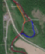
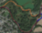
All of the below photos are depicting my GPS track from my race last year in 2018. You will see my path taken in Red, the normal flow of the river in Blue, and the first entrance or real cut if available in orange. There are also mile markers laid out so if you have a GPS watch like I do and didn't have time to scout these you can just make a note mileage wise where these cuts are so you are prepared for their upcoming arrival on the course.

The first cut is what most people refer to as the swamp cut. This cut is located you guessed it, in the swamp! haha. It is between the 4 and 5 mile mark as you can see from my GPS track. This cut is sometimes hard to scout prior to the race as if the water level is low you will need to walk this to scout. You will be surprised come race day however with the release of water from the Hospital how much the water comes up in this area and if there is some water in this it will be the fastest path even if you have to get out and run it. Remember though that you can only do this if there is enough water to keep your feet wet. Don't worry if you miss this cut as it is very early in the race and is worth less than 30 seconds. In 2017 my father and I were leading going into this cut and decided not to take it as it did not look like enough water to paddle in. Andy Hall and Steve Miller decided to take it and came out in front of us at the end of the cut. The hard part about not taking this cut is the difficult "S" turn that the normal river takes here where it is very narrow and there is a nasty eddie right by where the cut water comes back into the river.


Once your past the swamp cut you don't have to worry about a cut for another couple of hours. The next cut will be just after the Goodyear dam portage is located between the 25 and 26 mile mark. There are 2 entrances to this cut and the 1st entrance is the preferable entrance if it is open. Last year in 2018 my partner Matt Palmer and I decided to take the second entrance as you can see in the photos and we lost a significant amount of time here from the teams that took the 1st entrance. If you do miss both of the cut entrances you are probably looking at the 30-60 seconds lost by following the normal flow of the river. This cut is normally open but does close up in very low water.

The last cut is the "Green acres" cut. This is located just before Sydney and between mile 57 and 58. This is a cut that many choose to scout as the releases from the dams does not affect this cut to the same degree as the other 2. The "true" cut is only open in very high water conditions. There have only been 2 times the true cut has been open in the past decade and those were 2009 and 2013 when the water level was very high. I am told that when this is open it creates a significant advantage for those that take it compared to those that miss the opportunity. I personally have never had the chance to take it as every year that I have paddled the water level was not high enough to open this cut. If the "true" cut is not open the fastest route is normally the middle chute if there is not debris clogging it up. No worries here though if you take the normal flow of the river as the middle chute is only seconds faster than the normal river.

Well there you have it, those are the cuts. I want everyone to know that I share this information in hopes that it will help those that are interested in traveling for the Clinton but wish they had this information. It is my opinion that I should either beat or get beat by my competition based on my abilities as a paddler and not because of a lack local knowledge of where the "cuts" are. Even with the knowledge of these sections of the river you will still need to make split second decisions on what path to take come race day in the current conditions so having this information can only help present you the options but you must execute the proper plan to take full advantage of any "cut"